

Scenic Rim – a Rural Escape
The area which we call the Scenic Rim is an emerging rural escape set in the foothills of the Great Dividing Range and surrounded by world heritage listed national parks. Take this opportunity to look at some of the great National Park Walks that the Scenic Rim National Parks have to offer.
The region covers 4248sq km and is located an hour drive south of Brisbane and a like drive inland from the Gold Coast. Tamborine Mountain is one of the towns within the Scenic Rim.
There are great places to stay in the towns, and villages of the Scenic Rim. One of the great places to stay in the Scenic Rim is Amore B&B Mt.Tamborine – you will not be disappointed.
Eat Local Week
The region utilities this week to showcase the people and produce of the Scenic Rim. Experience the food and wine of this fertile region, which produces a bounty of fruit and vegetables, wines, milk and gourmet food.
Breathtaking Scenery
It is a must see tourist destination offering visitors plenty to see and do. A myriad of wineries and art galleries, expansive bushwalking tracks, state of the art equine facilities, growing rural communities and friendly country charm, the Scenic Rim region is a must visit destination.
Apart from Tamborine Mountain its main towns are Beaudesert, Boonah, Rathdowney, Kalbar, Canungra, Harrisville and Mount Alford. The region’s primary businesses are agricultural/horticultural production, the equine industry and tourism/ecotourism.
The Scenic Rim region contains more than 30,000 hectares of parkland, including national parks and council controlled parks. The region also contains three dams: Lake Moogerah, Lake Maroon and Wyaralong Dam.
A Great Place to Stay
Supported by a thriving economy, a farming industry and a vibrant arts community, the Scenic Rim has a strong community spirit and friendly locals.
Escape to the country and discover the quaint villages, hamlets and settlements in your backyard.
If it’s diverse scenery, fresh mountain air, antiques, old wares, great food and outstanding country hospitality that you are after, you are in the right place.
Local villages and hamlets have it all in generous quantities and in a unique environment bursting with personality. Stay for a day or maybe 2 or 3 days. There is heaps to do, to see and to experience.
Take to the road and explore this vibrant and diverse region put Destination Scenic Rim into your navigation device.
Tamborine Mountain
Country lanes meander throughout the mountain directing you to exciting outcomes. You’ll find boutique wineries, historic pubs, eclectic gift shops, beautiful art galleries and nature at its finest. Enjoy waterfalls, rainforest walking tracks and priceless views to the ranges and to the coast. If you are looking for a great place to stay then Amore B&B Mt Tamborine is for you. Tamborine Mountain is the shining jewel behind the Gold Coast. Full of lush rainforest, waterfalls and bush walks. Talk a day or 3 to explore and eat your way through this beautiful hinterland. Be sure to book your accommodation in advance as room space is limited – we recommend contacting businesses directly to arrange your stay. Tamborine Mountain is often referred to as the gateway to the Scenic Rim.
Canungra township
This 125-year old village is the gateway to Binna Burra Mountain Lodge, O’Reilly’s Rainforest Retreat and the magnificent Lost World Valley. See the historic Lahey Tramway Tunnel and enjoy Canungra’s wineries, hang gliding, arts, craft s and cafes. Canungra is nestled in the middle of the three major tourist destination, and is the gateway to the Gold Coast hinterland. Mount Tamborine, Lamington National Park, O’Reilly’s Guesthouse and Binna Burra. The township is also a meeting place for motor bike club rides, hanggliders, paragliders, birdwatchers and bushwalkers who visit the area annually to take advantage of what the Canungra Valley has to offer. A rodeo is organised each year in June. One of the origin of the town’s name comes from the Aboriginal word for small owls, “Caningera”. The most notable owl found in the area is the southern boobook owl, which appears in various logos and symbols associated with it. In 2005, the local Post Office released a special limited-release frank featuring Canungra and the boobook owl. However the word comes from the Yugambeh word gungunga meaning “a long flat or clearing.
Lost World and Christmas Creek
As far as names go, this one’s pretty accurate.The ancient trees which line the road begin to close in on you. The dramatic Razorback Mountain towers in the distance, and the road narrows as you head into this magical lost world.Then the vista opens up to reveal the lush, green valley, welcome to the wilderness end of the Lamington National Park. Lost World is a hidden plateau, a green shelf on Razorback Mountain, originally discovered by the O’Reilly family. An original old homestead not only still stands, but it offers farm stay experiences, including horseriding, milking, four-wheel driving, and a special insight into Lost World history. There are a number of accommodation options to choose from. You can take in a cooking class using the native produce or swim in the chill, pristine rock pools, let the natural creek spa soothe your joints after a long bushwalk. Hear the call of native birds amid an unforgettable backdrop. Darlington is a locality in the Scenic Rim Region of South East Queensland, Australia. The locality occupies a section of the upper Albert River valley where the river branches in two. The lower elevations in the north of Darlingston are around 160 m above sea level with the highest ridges and peaks reaching 600 m. Mount Alexander rises in the north east where a series of ridges extend from the Lamington Plateau. Here the upper and steeper slopes remain vegetated. Large areas in the south were the terrain is less rugged have been cleared. In the west the high point along Jinbroken Range forms a border with Hillview and Christmas Creek
Beaudesert
Seen by many as the entry point to the villages of the Scenic Rim. Be sure to visit the information centre and historical museum which displays vehicles, machines and tools of yesteryear, some going back 100 years. From Beaudesert go right, go left or simply drive straight ahead to explore the villages and hamlets of the Scenic Rim. Take the Kerry Road to the Lost World Valley to experience a magical natural environment which will linger long in your memory. Beaudesert is located on the Mount Lindesay Highway, some 91 kilometres (57 mi) south of Brisbane. The area sources its income predominantly from rural activities such as cropping, grazing and equine activities, as well as tourism. It boasts a racecourse, 50-metre swimming pool, public library, two gyms and mountain scenery. In the Logan River and Albert River valleys, Beaudesert is a regional hub serving surrounding communities such as Rathdowney, Kooralbyn, Canungra, Tamborine Mountain and Jimboomba. It is approximately 91 kilometres from Brisbane and connected by the Mount Lindesay Highway. The town of Beaudesert is located 46 m above sea level and has an average annual rainfall of around 916 mm per year. The temperature is around 30 degrees in summer and falls to around three degrees in winter. Generally the weather is mild, but some severe storms can arrive each summer. In the east of the locality is the decommissioned Nindooinbah Dam. The much larger Wyaralong Dam is situated roughly 14 km to the northwest of the town and was completed in 2011.
Rathdowney
Gateway to the wilderness areas of Mount Barney National Park. Rathdowney has an interesting Visitor Information Centre and Historical Museum. Here you can stock up on maps, brochures and suggested itineraries that will guide your exploration of this vibrant rural community and its incredible natural attractions. Rathdowney is a small town in south-eastern Queensland, Australia. It is on the Mount Lindesay Highway 32 kilometres (20 mi) south of Beaudesert at the base of the McPherson Range. It is located in the Scenic Rim local government area. At the 2011 census, it had a population of 434. There are many tours, farm stays, guest houses and other opportunities available for visitors to experience this region, which is about a 90-minute drive from Brisbane or the Gold Coast. In Autumn every year the population rises by several thousand for one day at the Rathdowney Heritage Festival, organised by the Rathdowney and District Historical Association (RADHA), who also run an information centre with information on natural heritage, indigenous heritage and history of white settlement from the time of the first pioneers to present day. Mount Maroon is 12 km west. At 966 m the summit provides 360 degree views.
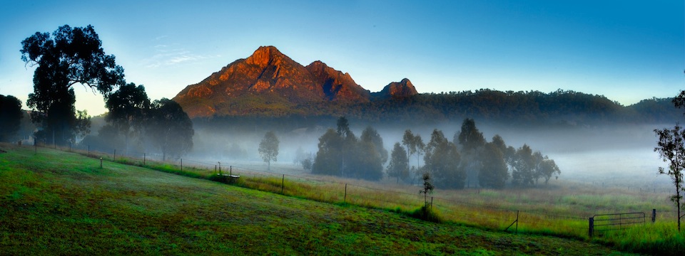
Mt. Barney
Mt Barney National Park is a World Heritage listed wilderness park.The mountain is surrounded by valleys, rock pools and woodland forest, and a diverse number of tourism based businesses operate in the foothills of this dramatic region.Say hi to an alpaca, learn to make authentic Italian cuisine, experience bird watching, walk through a local olive grove and take some fresh-pressed oil with you. Drink wine made from Mt Barney grapes, try abseiling or just relax and enjoy nature in the wild. There’s plenty of places to stay for a night, warm, luxurious stop-overs with generous hosts who will soothe body and soul after a busy day. Mount Maroon rises to 966 m above sea level to the west of Barney View. This western section is protected within Mount Barney National Park. Mt Barney’s A World Apart Festival celebrates with a packed offering of free food tastings, live music, open gardens and much more. Billed as a Country Festival, A World Apart features various properties in the spectacular Mt Barney region in the southern Scenic Rim. Join bush tucker tours, enjoy one of Pietro’s famous wood fired pizzas, tour the sculpture garden, or try a slice of Lemon Myrtle meringue pie. Book in for a farm tour. Access to all events is free. BYO cooler to store your fresh farm-bought produc for your picnic in the park. There are lodges that are perfect for larger gatherings and cottages for the romantics. Bring the kids and visit a farmstay where you’ll get an insight into the workings of a busy rural property.
Lamington National Park
The Lamington National Park is home to the Scenic Rim’s most diverse and accessible natural habitat. It is made up of two sections, Green Mountains and Binna Burra. Green Mountains is located on the western side of the Lamington Plateau in an area called O’Reilly, after the O’Reilly family who first settled the land in the early 1900s. Binna Burra is located on the eastern side of the plateau, closest to the Gold Coast. The Lamington National Park was declared in 1915 and covers 20,590 hectares of land. It features many walking tracks along the McPherson Range, and dramatic lookouts which offer sweeping views over the Gold Coast, South-East Queensland and as far as Northern NSW. When you stay at AmoreB&B a visit to the Lamington National Park is but a short drive away and we have a Map Guide to help you on your way. The Lamington National Park is a national park, lying on the Lamington Plateau of the McPherson Range on the Queensland/New South Wales border in Australia. From Southport on the Gold Coast the park is 85 kilometres (53 mi) to the southwest and Brisbane is 110 kilometres (68 mi) north. The 20,600 hectares (51,000 acres) Lamington National Park is known for its natural beauty, rainforests, birdlife, ancient trees, waterfalls, walking tracks and mountain views. It’s known for its section of the ancient Gondwana Rainforests, home to the rare Albert’s lyrebird. Trails in the park’s 2 areas, Binna Burra and Green Mountains, criss-cross the McPherson Range. The Border Track offers mountain views. The Caves Circuit overlooks the Coomera Valley. The tumbling Moran’s Falls can be seen from the Python Rock lookout.
Mount Alford
What this village lacks in size it makes up for in character. This historic area, settled in the 1880s, features the Mount Alford School – founded in 1888 – which continues to operate today. The Farmers’ Market, the Mt Alford Pub, the Kooroomba Winery and the Lavender Farm are all great places to visit.
Boonah
If seeing a one-off timepiece takes your fancy, Boonah is the home of sculptor Christopher Trotter’s quirky creation – The Blumbergville Clock – a masterpiece of functional art. Include visits to local art galleries, the donkey farm and stock up on freshly grown produce and delicious home-made jams and relishes. Boonah is positioned near the Fassifern Valley, McPherson Range and Main Range. It is surrounded by hills, including Mount French and other Moogerah Peaks. Frog Buttress is a popular rock climbing cliff on the north-west side of Mount French. Heart of South East Queensland’s beautiful Scenic Rim. An easy drive one hour from Brisbane and the Gold Coast, the Boonah region is perfect for a day trip, weekend getaway or an even longer stay. With stunning mountain and country scenery, a large range of accommodation, country pubs, food outlets, wineries, artwork, bushwalking trails, national parks and other attractions, you will go home relaxed and refreshed. Take time out to explore how life should be!
Kalbar
Rich in German history dating back to 1876, Kalbar offers great views of the Scenic Rim region and boasts many heritage-listed buildings. The town has shops, cafes, galleries, parks, gardens and many attractions including the heritage-listed Wiss Emporium. Enjoy a coffee with Belgian waffles or visit the Art Café for delicious Dutch croquettes. Kalbar is located near the Cunningham Highway and directly north of Mount French in the Fassifern Valley. The town is part of the Scenic Rim Region local government area. At the 2011 census, Kalbar had a population of 723 Settlement began at the location in 1876 and by 1890 a small town had developed. The town was once known as Fassifern Scrub and then Engelsburg after the first settler of the town. The town has a very rich German history, having been established “almost exclusively” by German settlers, reflected today in the many Anglo-German road and street names as well as the many local German settler descendant surnames. The name changed to Kalbar because of anti-German sentiment in 1916., though only first applied to the railway station. The Engelsberg School of Arts did not change to the Kalbar School of Arts until July, 1918. The Mount Edwards railway line reached the town in 1916.
Harrisville
A village with character, Harrisville has a diverse mix of shops including quaint antique and collectable stores. Visit the Historic Museum or one of the excellent wineries. Pick up some locally grown organic vegetables, a bunch of native flowers or simply take in the fabulous scenery. Harrisville is believed to be named after brothers John Harris (1819–1895) and George Harris (1831–1891) who had a store and cotton ginnery in the area. Cotton was a valuable crop at that time as the American Civil War had created a worldwide shortage. The area formed part of the old Mount Flinders sheep station established by William Wilson (and his brother Robert) around 1844,[4] soon after the Moreton Bay penal colony closed. Some of the land from this station became available to selectors in December 1860 with provision of the Ipswich Agricultural Reserve. In 1863 Robert Dunn selected a portion from this Reserve from which the Harris brothers purchased their land in 1870. Prior to this settlement and others throughout the Moreton region, a survey baseline of 3 miles (4.8 km) in 1839 was marked out on the floodplain, then known as Normanby Plains, which now forms part of Harrisville, together with Wilsons Plains and Radford to the south. It was supervised by the surveyor Robert Dixon as the basis of a trigonometrical survey starting with Flinders Peak to the east and Mount Walker (then Mount Forbes) to the west which began the accurate interior mapping of Queensland. A monument to this work “In the Steps of Our Forefathers” is situated just west of the Harrisville township on the Warrill View – Peak Crossing Road, along where the baseline passed. Harrisville Post Office opened on 1 August 1873 (a receiving office had been open from 1871). Queensland’s first branch railway line reached Harrisville in 1882. A private hospital operated from 1911 until 1973.
Aratula
Aratula is a small town and locality in the Scenic Rim Region, Queensland, Australia. about 60 kilometres (40 mi) southwest of Ipswich, just east of Cunninghams Gap. The small village of Aratula, at the foot of Cunningham’s Gap in South East Queensland, has long served as a resting place for weary travellers crossing the Great Dividing Range. The town offers a range of accommodation options including caravan parks and motels. Aratula is surrounded by beautiful natural areas including the Moogerah Peaks National Park and Main Rain National Park. Located in the Fassifern Valley, the four peaks of Moogerah have been carved from volcanic rock and the inaccessibility of the area has spared the natural vegetation from clearing by European settlers. The Park shelters eucalypt forest, sheer cliffs, and patches of rainforest. The cliffs on Mount French are a favourite with rock climbers, but not for the inexperienced or faint of heart. Palm Gorge on nearby Mount Greville in home to a nearly pure strand of Picabeen Palms.
Kooralbyn
Kooralbyn is a locality in the Scenic Rim local government area in Queensland, Australia. It is approximately 22 kilometres (14 mi) south-west of Beaudesert, itself some 64 kilometres (40 mi) south of Brisbane in South East Queensland, and 56 kilometres (35 mi) west of Queensland’s Gold Coast. Kooralbyn is situated at the southern end of the Teviot Range. In 1979, work began on a resort that featured a diverse range of recreational facilities. 55 hillside holiday houses were completed in 1982 and designed by Harry Seidler. In 1991 a new hotel was added to the resort. In July 2008 the resort and golf course closed and went into liquidation. In June 2014 Peter Huang, founder of the Yong Real Estate group, settled on the purchase of the Kooralbyn Resort. Which he then went on to dedicating time and money towards updating the facilities and renovating the rooms to a modern standard before the resort was re-opened in mid 2016.
Moogerah
Moogerah is derived from the Aboriginal word Moojirah, meaning “home of the thunderstorm. The dam is located above the Fassifern Valley, approximately 60 kilometres southwest of Ipswich. Aratula is the nearest town, approximately 11 kilometres from the dam and the nearest major centre is Boonah. The primary inflow of the reservoir is the Reynolds Creek, a tributary of the Bremer River. Amenities adjacent to the dam and reservoir include a caravan park. Camp Moogerah is on the eastern shore of the lake, offering cabin accommodation and outdoor activity camps for schools, churches, youth groups, sports clubs etc. On the western shore are School Camps Queensland and Camp Laurence which offer group accommodation camps with educational and adventure activities for school students, family and church groups.

Enquire about Gift Vouchers now …
Tel 07 5545 2330