

Best Scenic Rim National Park Walks
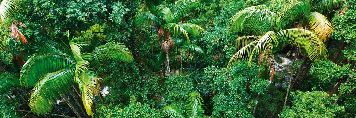
There are many National Park Walks located within the area that we know as the Scenic Rim. Below we give you a little glimpse at 27 of our National Park Walks The bush walking tracks take you through rainforests with large strangler figs, piccabeen palm groves and tall trees festooned with vines, ferns and orchids. The National Parks are also a bird watchers paradise.
Three of the National Park Walks are a short stroll from Amore B&B.
Base your stay at Amore the most central accommodation venue on Mt. Tamborine.
Curtis Falls Waterfall and Bush Walking Trail – Joalah Section – 1.5 km Curtis Falls Walk (return) – 130 steps.
The Joalah (haunt of the Lyrebird) section of the National Park features the 1.5 km Curtis Falls Walk (return). It descends to a rock pool at the base of the falls, offering fine views of the basalt rock face.
Brush-turkeys can be seen along the Joalah Circuit (4 km) which links up with the Curtis Falls Walk.The Joalah section features majestic wet eucalypt forest, dominated by giant flooded gums, surrounded by lush tropical rainforest with piccabeen palms, ferns and strangler figs.
Located within the Gallery Walk Environs Precinct with access off Eagle Heights Road or Dapsang Drive – toilets available. If you need a map or an information sheet you will find one in your room. It features in our Walk to a Waterfall POST and MAP GUIDE
The Waterfall is a short stroll from Amore B&B.
Macdonald Bush Walking Track – 1.4 km circuit (allow 30 minutes), easy grade.
This relatively flat walking track passes through rainforest with large strangler figs, piccabeen palm groves and tall trees festooned with vines and ferns. The track is ideal for birdwatchers and visitors seeking a quiet rainforest walk away from road noise and large numbers of people.
Instantly calming, the peaceful subtropical rainforest of the MacDonald section is the perfect place to relax and discover a fascinating and rich ecosystem. Giant trees such as strangler figs and yellow carabeens rise as high as 30 m into the sky, blocking out the sunlight with a ceiling of leaves. A shady, humid world exists beneath the closed canopy. Climbing vines and epiphytes cling to the giant trees high above the ground where light is easier to come by. Delicate ferns and fungi cluster on the darkened rainforest floor.
Lush groves of piccabeen palms thrive along the waterlogged areas. Located within the Gallery Walk Environs Precinct access is from Wongawallen Road at the northern fig-tree roundabout of Gallery Walk, parking is about 200 metres down the road opposite the Heritage Center. This Park features in our Olde Eagle Heights Walking Trail POST and MAP GUIDE.
The Track is a short stroll from Amore B&B
 Palm Grove Rainforest Bush Walking Track 2.6km circuit (allow one hour). Easy grade.
Piccabeen palm groves and rainforest with emergent strangler figs and distinctively buttressed yellow carabeens feature on this walk. Palm Grove Avenue is the main access point and car park for this walking track.
The Palm Grove section is named after the piccabeen palmArchontophoenix cunninghamiana that grows abundantly here. These palms have aerial roots that are exposed above the soil surface. This unusual feature allows them to absorb oxygen despite the waterlogged soils of this area. Parking for buses and caravans is not available. The Park features in our Olde Eagle Heights Walking Trail POST and MAP GUIDE.
Palm Grove National Park is but a short stroll from Amore B&B.
Cameron Falls Waterfall and Bush Walking Track – The Knoll Section – (3 km)
The Knoll section of the National Park is located in the north-west of North Tamborine. It contains the Cameron Falls Circuit (3 km) which offers fine views, rainforest environs, open forest and the occasional black skink sunbathing on the rocks.Lush subtropical rainforest is sustained by ideal conditions at The Knoll—high rainfall, rich volcanic soil and sheltered gullies.
At the halfway point of your bush walk you will be at Cameron Falls Waterfall — views to the border ranges and the majesty that is Cameron Falls. Following heavy rain the Falls are a pumping and the cascading white water framed by the rock face and rainforest trees makes an awesome sight. Put a visit to Cameron Falls on your bucket list.
Tall trees such as strangler figs and piccabeen palms create the forest’s closed canopy, limiting light reaching the forest floor. Plants and animals found here have adapted to survive in this shaded, humid environment.Open eucalypt forest grows on the exposed north-west cliffs of The Knoll.
Huge eucalypt trees including flooded gums, spotted gums, scribbly gums, bloodwoods and ironbarks dominate this dry forest. A large amount of sunlight streams through the open canopy, allowing wattles and kangaroo grass to flourish on the forest floor.The Knoll also contains stands of the forest she-oak Allocasuarina torulosa.
The small brown cones and winged seeds of this tree are an important food source for glossy black-cockatoos Calyptorhychus lathami.The Knoll is home to one of Australia’s beautiful native flowering trees, the lacebark Brachychiton discolour. In summer this deciduous tree is covered in large pink bell-shaped flowers and is a valuable food plant for tailed emperor butterfly Polyura sempronius larvae.
For access turn off Main Western Road into Main Street, continue past the shops to the residential area where it becomes Knoll Road, keep left where the road forks and you are there. Adequate parking, toilets, both open and covered picnic settings, electric BBQs and lookouts to Brisbane and the Western Ranges.
A favourite with both locals and visitors.
Witches Falls – Waterfall and Bush Walking Track – 3.1km/1 hour.
The Witches Falls section became Queensland’s first national park in 1908. The main walking track here is the Witches Falls Circuit (3 km. moderate grade) which winds down a steep slope through closed in forest into rainforest with cyclad groves, seasonal lagoons, enormous strangler figs and palm groves en-route to the falls. Lush subtropical rainforest, featuring large red cedar trees and strangler figs, thrives in the Witches Falls section.
Eucalypt forest and open forests of banksia trees grow in the poorer nutrient soils where conditions are generally drier. After heavy rain, seasonal lagoons at the Witches Falls section fill with water and the lagoons spring to life. The Witches Falls Waterfall is reached just past the northern return track T-junction.
Spend time at the viewing platform not only for the falls but to take in the views to the Western Ranges. You will return via the northern exit bushwalking track zigzagging up the sloop through the dense rainforest. The Circuit starts from the picnic area on Main Western Road – electric BBQs, picnic tables and toilets available.
Queensland’s 1st National Park.
 Cedar Creek – Rock Pools and Cascades
One of the most delightful walking tracks in the whole Tamborine area is the Cedar Creek Circuit (3.2 km) which explores the creek’s various cascades, rock pools and plant communities, such as open and dry rainforest and hoop pines. Cedar Creek Waterfalls tumble (gently rather than spectacularly) down into a gully.
Magnificent cascades rock pools and waterfall. You descend down through open forest and dry rainforest and arrive at the popular swimming holes after crossing extensive jumbled rock scree slopes just before the creek. The 1.5 km Rock Scree Walk intersects with the circuit walk for a potential detour.
At Cedar Creek section, tall, sun-drenched gum trees burst with vibrant flowers and brush box, iron barks, bloodwoods and forest red gums are well suited to the ancient and nutrient-poor soil.
The fragrant, open eucalypt forest gives way to dry rainforest where fragile orchids and ferns decorate the forest floor. Fertile soil washed downstream from the mountain top supports patches of dry rainforest growing along Cedar Creek. Trees such as grey myrtle Backhousia myrtifolia and smooth tuckeroo Cupaniopsis serrata reach towards the sky and form a canopy, sheltering delicate rainforest plants in the understorey.

Lower Portals Track – Mt Barney National Park (7.4km/3 hours)
This track leaves from the Lower Portals car park and goes to the Lower Portals, a beautiful pool along a gorge on Mount Barney Creek. This walk has moderate to steep gradients.
A parking area and toilets are available.
Cronan Creek Track – Mt Barney National Park (13km/5 hours)
From Yellow Pinch car park, a pleasant walk along the fire trail leads you past the base of South Ridge into cool green rainforest.
(Note: The climb up South Ridge is rugged and steep and for experienced walkers only). Parking, picnic area, cooking area and toilets are available.
Mee-bor-rum Circuit – Moogerah Peaks National Park – Mt French section (720m/15 mins)
This circuit track is one of our National Park Walks and passes through heathland and features the East cliff lookout with views of Tamborine, Lamington and Mount Barney.
Care must be taken at the lookout as it is a natural feature and has no handrails. Further along the track a circular platform with seating provides views of the heathland and southern section of Mount French.
Wheelchair access on this track is only possible to the heathland—beyond here the track is rough and uneven. Parking area, BBQ (wood), picnic area, toilets, natural lookout, campground area and water is available.
 Mt Edwards Summit – Moogerah Peaks National Park – Mt Edwards section (6km/3.5 hours)
Mount Edwards is accessible from the Moogerah Dam picnic area at the end of Moogerah Connection Road. From the picnic area walk across the Moogerah Dam wall to the park entrance. This walk is suitable for experienced walkers only and requires a reasonable level of fitness. There are no formed tracks, signs or facilities so you must be self-reliant.
Warning! There are sheer cliffs and slippery rocks particularly after rain. One slip could be fatal—serious injury or death may result from walking near the cliff edge. Keep to the track—supervise children closely.
Cotswold Track – Mt Barney National Park Walks – Mount Maroon summit (6km/8 hours)
In spring this summit provides spectacular wildflower displays set against the craggy peaks of the Scenic Rim. Allow a full day to reach the summit safely and to return to your vehicle.
Parking area and toilets are available.
North Cliff Track – Moogerah Peaks One of our National Park Walks – Mt French section (720m/15 mins)
This track leads to Logans lookout with excellent, panoramic views over the Fassifern Valley, with the Main Range escarpment to the west and Flinders Peak and beyond to the east. North Cliff track is suitable for wheelchairs with assistance.
The track is suitable for wheelchairs with assistance. Parking area, BBQ (wood), picnic area, toilets, natural lookout, campground area and water is available.
Rainforest  Circuit – Main Range National Park – Cunningham’s Gap (1.6km/30 mins)
The circuit commences at the eastern end of the crest carpark. It passes the Allan Cunningham monument, and is the beginning of an extensive track system on the northern side of the Gap. The Fassifern Valley lookout track forms the eastern part of the circuit. Turn left at the base of the stairs to take the easiest way around the circuit.
Parking area and toilets available.
Fassifern Valley Lookout – Main Range National Park (1.2km/20 mins)
Commencing at the crest carpark, the Fassifern Valley lookout provides a spectacular view over the Moogerah Peaks, Fassifern Valley and Lake Moogerah. The track commences at the eastern end of the crest carpark and forms the eastern part of the Rainforest circuit.
Parking area, toilets, constructed lookout available.
Mount Cordeaux Track – Main Range National Park Walks – Cunningham’s Gap (6.8km/2.5 hours)
Mount Cordeaux (1135 m) is known to Aboriginal people as Niamboyoo. Branching off the Rainforest Circuit, the track zigzags through rainforest to the exposed upper slopes, ending at a lookout on the southern side. The cliff face of Mount Cordeaux is spectacular in spring and early summer when the giant spear lilies (Doryanthes palmeri) are in flower.
Take care at the cliff edge. Parking area and toilets are available.
 Mount Mitchell Track – Main Range National Park – Cunningham’s Gap (10.2km/3 hours)
A graded walking track to the twin peaks of Mount Mitchell begins on the southern side of the highway. Take care when crossing the highway. Rainforest and open eucalypt forest will be encountered on this track, which ends on a knife-edge ridge above a sheer cliff on the east peak of Mount Mitchell (1168 m). This peak is known as Cooyinnirra to the Aboriginal people.
Take care at the cliff edge. Parking area and toilets available.
Heritage Trail – Main Range National Park – Spicer’s Gap (3.2km/1 hour)
From the Governor’s Chair carpark, an interesting self-guiding walk, showing various road construction methods, follows the historic road.
Parking area is available.
Sylvesters Lookout – Main Range National Park – Goomburra (940m/30 mins)
Sylvesters lookout offers magnificent views over the coastal plains below including the southern tip of Lake Moogerah and the rugged border ranges to the south. The track starts from Lookout Road—a 4.7 km drive from the Kurrajong picnic area.
This road is a dry weather road only and is closed by locked gate near Kurrajong picnic area during wet weather.
Caves Circuit – Lamington National Park Walks – Binna Burra section (5km/1.5 hours)
From the park’s information centre, this interesting track winds up through open forest and rainforest to emerge on the road near the Binna Burra Mountain Lodge road entrance. Alternatively, begin this track from the Binna Burra Mountain Lodge road entrance and return via Binna Burra Road. Caution: this track contains unstable surfaces. Rockfalls may occur on the track and in Kweebani Cave. For your safety, avoid lingering near the cave – move along the track and view the cave from a safe distance.
The track provides excellent views into the Coomera Valley and passes a large red cedar and fine specimens of other rainforest tree species. The major cliff line opposite is of a flow of rhyolite and deposits of boulders and ash (tuff) can be seen in overhanging caves. Possibly the largest intact stand of hoop pine (Araucaria cunninghamii) can be seen along the Darlington Range. White-throated treecreepers, members of one of the oldest groups of songbirds, are frequently seen on this track. Koalas are often seen in open forest areas along the walk.
Take care when walking down the bitumen road to return to the start of the circuit, especially on weekends when traffic is heavy. A self-guiding brochure produced by the Lamington Natural History Association for this circuit is available at the national park’s information centre, kiosk and Binna Burra Mountain Lodge.
Bellbird Lookout Track – Lamington National Park Walks – Binna Burra section (2km/1hour)
This track branches off the Ships Stern circuit and descends through rainforest and open forest before emerging suddenly at Bellbird lookout. This natural lookout that has no handrails and is above a very high, steep cliff (this lookout and most of the track is on Binna Burra Lodge land and is not part of the national park).
Please keep children under close supervision and keep well away from the cliff edge. From here you get an excellent view of Ships Stern, Turtle Rock, Egg Rock (Kurraragin) and Numinbah Valley.
This is a brilliant opportunity to view what millions of years of erosion, landslides and weathering have created. These continuing geological processes will continue to shape what you see before you. Hoop pines (Araucaria cunninghamii) can be seen from the lookout, growing on the exposed northern slopes. Harvesting of hoop pine and red cedar (Toona ciliata) led to the initial European settlement and ultimate clearing of Numinbah Valley for agriculture..
Ships Stern Circuit – part of the Gold Coast Hinterland Great Walk – Lamington National Park – Binna Burra section (21km/8 hours)
Stern circuit starts 300m back from the road’s end (opposite the road entrance to Binna Burra Mountain Lodge). It descends into Kurraragin Valley (Nixon Creek) where you will see fine stands of pIpswich City Councilabeen palm (Archontophoenix cunninghamii), large red cedar (Toona ciliata), and majestic flooded gum (Eucalyptus grandis).
Lower Ballunjui Falls, 5.3km from the track entrance, is reached by a short side-track that branches off the main track. On the Ships Stern Range, which is formed of rhyolite, the rainforest gives way to eucalypt forest with a dense understorey of spring-blooming wildflowers. Lookouts provide views into Numinbah and Kurraragin valleys, giving us a glimpse of a stage in the continuing erosion of the Tweed Shield Volcano.
The unmistakable Egg Rock is a rhyolite plug that formed in one of the subsidiary vents of this once massive shield volcano. The track continues through rainforest and open forest with another side-track (1.3km one way) providing access to the top of Ballunjui Falls before joining the Border Track to return to Binna Burra. This track forms part of the Gold Coast Hinterland Great Walk, arrow markers indicate the route.
Please do not attempt this walk unless you are a Great Walker and have a copy of the Gold Coast Hinterland Great Walk Topographic Map.
Tree Top Walkway – O’Reilly’s Rainforest Retreat (1.5km/30 mins)
The Booyong Boardwalk, featuring some excellent interpretive signage, leads you from the front of O’Reilly’s Rainforest Retreat to the walkway, which is a series of suspension bridges that take you 16m up into the rainforest canopy. The adventurous can climb ladders to a crows nest like platform in a fig tree 30m above the ground.
Not recommended for those who suffer from a fear of heights.
Python Rock Track – Lamington National Park Walks – Green Mountains section (3.4km/1 hour)
This track leaves the Lamington National Park Road 800m downhill from the national park’s information centre. Some parking is available at the track entrance. Python Rock lookout (1.6km from the track’s entrance) provides views of Morans Falls, Castle Crag and Lost World. Views from the lookout highlight the geological processes of erosion, including valley widening and escarpment formation.
This track passes through a closed rainforest community into an open eucalypt forest where fire-adapted species such as grasstrees, hakeas and various wildflowers grow. The guttural “popping” of the masked mountain frog (Kyarranus loveridgei) can be heard on wet or moist days in late spring and summer. These ancient frogs are members of the Gondwanan family commonly known as southern frogs.
Morans Falls – Lamington National Park Walks – Green Mountains section (4.6km/1.5 hours)
This track leaves the Lamington National Park Road 800m downhill from the national park’s information centre. Some parking is available at the track entrance. An excellent view of Morans Falls and Morans Creek gorge can be seen from the constructed lookout located before the creek crossing.
Layers of ancient volcanic lava flows are also visible; the more resistant have formed small cliff-lines along the valley, and is best seen at the second lookout located at the end of the track. Please keep to the track as short cuts create erosion.
Box Forest Circuit – Lamington National Park Walks – Green Mountains section (10.9km/4 hours)
This track branches from the Border Track 1.8km from the track entrance and leads directly to Picnic Rock and Elabana Falls. It runs through rainforest and past impressive stands of smooth, pink-barked brush box (Lophostemon confertus) before reaching the falls. Similar brush box in other parts of the World Heritage area have been radiocarbon dated at 1500 years, making these giant trees the oldest ever carbon-dated on Australia’s mainland. If you intend walking this entire circuit, walk in a clockwise direction and exit via Elabana Falls and Picnic Rock.
 Tullawallal Circuit – Lamington National Park Walks – Binna Burra section (5km/1.5 hours)
Visit the most accessible cool temperate rainforest in Lamington and the closest patch of this forest type to Binna Burra. At the trailhead take the right branch of the Rainforest circuit and follow signs to the Tullawallal circuit. The pocket of Antarctic beech (Nothofagus moorei) on the summit is the northernmost location of this species in Australia.
These trees are one of our remaining links with the ancient forests of Gondwana. Nothofagus forests were once widespread across the continent and provided a habitat for many animals that have long since disappeared from our landscape. From Tullawallal, return to the track junction, turn left. At the second junction turn left onto the Border Track and continue to the Binna Burra carpark.
Rainforest Circuit – Lamington National Park Walks – Binna Burra section (1.2km/30 mins)
For a quick introduction to the “typical” warm subtropical rainforest of Lamington, follow the Border Track for 500m, then branch right and return to the picnic area along the rainforest circuit track. Bowerbirds and catbirds are commonly heard.
A self-guiding brochure produced by the Lamington Natural History Association (LNHA Inc.) is available at the national park information centre, campground kiosk and Binna Burra Mountain Lodge.
Lower Bellbird Circuit – Lamington National Park Walks– Binna Burra section (12km/4 hours)
This track branches off the Ships Stern circuit 3.7km from the track entrance. The track passes through a patch of dry rainforest, regarded as an example of the rise of the “dry adapted” flora now widespread in Australia. Follow the track below Bellbird lookout and emerge at a clearing, once a dairy farm.
The circuit returns via the Binna Burra Road. Please note that choosing to return via the Caves track adds 1.6km to the walk. This track forms part of the Gold Coast Hinterland Great Walk, arrow markers indicate the route.
Please do not attempt this walk unless you are a Great Walker and have a copy of the Gold Coast Hinterland Great Walk Topographic Map.