
Waterfalls and Bush Walks
Lace up your boots and lets go walking. – Don’t get left behind
Six designated bush walking tracks are located within the Tamborine National Park. The bush walking tracks take you through rainforests with large strangler figs, piccabeen palm groves and tall trees festooned with vines, ferns and orchids. The National Parks are also a bird watchers paradise. Three of the bush walking tracks are a short stroll from Amore.
All bush walking tracks are easy to moderate and vary in distance from 1.4 kilometers (30 minutes) to 3.10 kilometers (one hour).
See the footer on this page for posts detailing an updated list of our current self-drive and local walking maps.
The main sections to visit are detailed below. Want to see one of our Warterfalls? This (Video No 11) will wet your appetite.
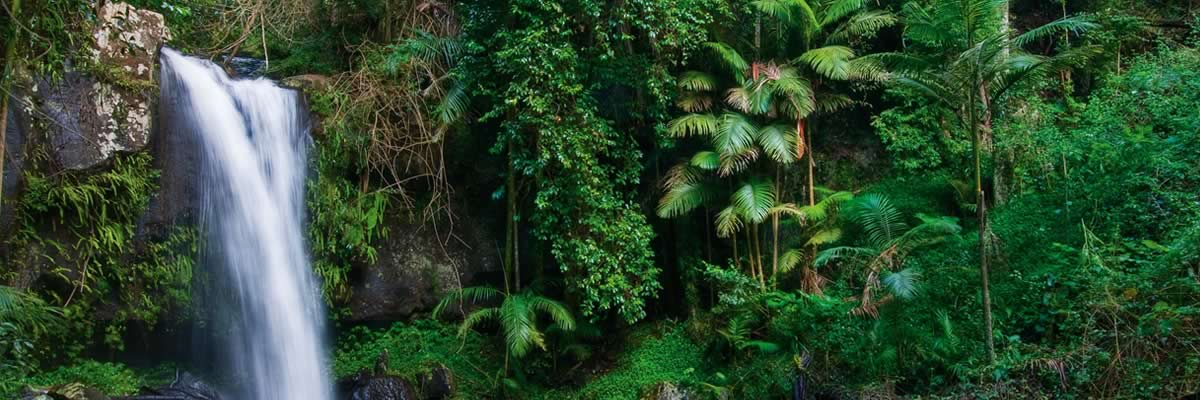
Curtis Falls Waterfall and Bush Walking Trail – Joalah Section
The Joalah (haunt of the Lyrebird) section of the National Park features the 1.5 km Curtis Falls Walk (return) .
It descends to a rock pool at the base of the falls, offering fine views of the basalt rock face. Brush-turkeys can be seen along the Joalah Circuit (4 km) which links up with the Curtis Falls Walk.The Joalah section features majestic wet eucalypt forest, dominated by giant flooded gums, surrounded by lush tropical rainforest with piccabeen palms, ferns and strangler figs.
Located within the Gallery Walk Environs Precinct with access off Eagle Heights Road or Dapsang Drive – toilets available. If you need a map or an information sheet you will find one in your room. It features in our Walk to a Waterfall POST and MAP GUIDE
The Waterfall is a short stroll from Amore B&B.
Macdonald Bush Walking Track
1.4 km circuit (allow 30 minutes), easy grade. This relatively flat walking track passes through rainforest with large strangler figs, piccabeen palm groves and tall trees festooned with vines and ferns. The track is ideal for birdwatchers and visitors seeking a quiet rainforest walk away from road noise and large numbers of people.
Instantly calming, the peaceful subtropical rainforest of the MacDonald section is the perfect place to relax and discover a fascinating and rich ecosystem. Giant trees such as strangler figs and yellow carabeens rise as high as 30 m into the sky, blocking out the sunlight with a ceiling of leaves. A shady, humid world exists beneath the closed canopy. Climbing vines and epiphytes cling to the giant trees high above the ground where light is easier to come by. Delicate ferns and fungi cluster on the darkened rainforest floor.
Lush groves of piccabeen palms thrive along the waterlogged areas. Located within the Gallery Walk Environs Precinct access is from Wongawallen Road at the northern fig-tree roundabout of Gallery Walk, parking is about 200 metres down the road opposite the Heritage Center. This Park features in our Olde Eagle Heights Walking Trail POST and MAP GUIDE.
The Track is a short stroll from Amore B&B
Palm Grove Rainforest Bush Walking Track
2.6km circuit (allow one hour). Easy grade. Piccabeen palm groves and rainforest with emergent strangler figs and distinctively buttressed yellow carabeens feature on this walk. Palm Grove Avenue is the main access point and car park for this walking track.
The Palm Grove section is named after the piccabeen palm Archontophoenix cunninghamiana that grows abundantly here. These palms have aerial roots that are exposed above the soil surface. This unusual feature allows them to absorb oxygen despite the waterlogged soils of this area. Parking for buses and caravans is not available. The Park features in our Olde Eagle Heights Walking Trail POST and MAP GUIDE.
Palm Grove National Park is but a short stroll from Amore B&B.
Cameron Falls Waterfall and Bush Walking Track – The Knoll Section
The Knoll section of the National Park is located in the north-west of North Tamborine. It contains the Cameron Falls Circuit (3 km) which offers fine views, rainforest environs, open forest and the occasional black skink sunbathing on the rocks.Lush subtropical rainforest is sustained by ideal conditions at The Knoll—high rainfall, rich volcanic soil and sheltered gullies.
At the halfway point of your bush walk you will be at Cameron Falls Waterfall — views to the border ranges and the majesty that is Cameron Falls. Following heavy rain the Falls are a pumping and the cascading white water framed by the rock face and rainforest trees makes an awesome sight. Put a visit to Cameron Falls on your bucket list.
Tall trees such as strangler figs and piccabeen palms create the forest’s closed canopy, limiting light reaching the forest floor. Plants and animals found here have adapted to survive in this shaded, humid environment.Open eucalypt forest grows on the exposed north-west cliffs of The Knoll.
Huge eucalypt trees including flooded gums, spotted gums, scribbly gums, bloodwoods and ironbarks dominate this dry forest. A large amount of sunlight streams through the open canopy, allowing wattles and kangaroo grass to flourish on the forest floor.The Knoll also contains stands of the forest she-oak Allocasuarina torulosa.
The small brown cones and winged seeds of this tree are an important food source for glossy black-cockatoos Calyptorhychus lathami.The Knoll is home to one of Australia’s beautiful native flowering trees, the lacebark Brachychiton discolour. In summer this deciduous tree is covered in large pink bell-shaped flowers and is a valuable food plant for tailed emperor butterfly Polyura sempronius larvae.
For access turn off Main Western Road into Main Street, continue past the shops to the residential area where it becomes Knoll Road, keep left where the road forks and you are there. Adequate parking, toilets, both open and covered picnic settings, electric BBQs and lookouts to Brisbane and the Western Ranges.
A favourite with both locals and visitors.
Witches Falls – Waterfall and Bush Walking Track
The Witches Falls section became Queensland’s first national park in 1908. The main walking track here is the Witches Falls Circuit (3 km. moderate grade) which winds down a steep slope through closed in forest into rainforest with cyclad groves, seasonal lagoons, enormous strangler figs and palm groves en route to the falls.Lush subtropical rainforest, featuring large red cedar trees and strangler figs, thrives in the Witches Falls section.
Eucalypt forest and open forests of banksia trees grow in the poorer nutrient soils where conditions are generally drier. After heavy rain, seasonal lagoons at the Witches Falls section fill with water and the lagoons spring to life.The Witches Falls Waterfall is reached just past the northern return track T-junction.
Spend time at the viewing platform not only for the falls but to take in the views to the Western Ranges. You will return via the northern exit bushwalking track zigzagging up the sloop through the dense rainforest. The Circuit starts from the picnic area on Main Western Road – electric BBQs, picnic tables and toilets available.
Queensland’s 1st National Park.
Cedar Creek – Rock Pools and Cascades
One of the most delightful walking tracks in the whole Tamborine area is the Cedar Creek Circuit (3.2 km) which explores the creek’s various cascades, rock pools and plant communities, such as open and dry rainforest and hoop pines. Cedar Creek Waterfalls tumble (gently rather than spectacularly) down into a gully.
Magnificent cascades rock pools and waterfall. You descend down through open forest and dry rainforest and arrive at the popular swimming holes after crossing extensive jumbled rock scree slopes just before the creek. The 1.5 km Rock Scree Walk intersects with the circuit walk for a potential detour.
At Cedar Creek section, tall, sun-drenched gum trees burst with vibrant flowers and brush box, iron barks, bloodwoods and forest red gums are well suited to the ancient and nutrient-poor soil.
The fragrant, open eucalypt forest gives way to dry rainforest where fragile orchids and ferns decorate the forest floor. Fertile soil washed downstream from the mountain top supports patches of dry rainforest growing along Cedar Creek. Trees such as grey myrtle Backhousia myrtifolia and smooth tuckeroo Cupaniopsis serrata reach towards the sky and form a canopy, sheltering delicate rainforest plants in the understorey.
Another great bush walking track.
(Walking Tracks and Mt. Tamborine National Park information is based upon public information available from the Government Department)
We have Bush Walking Track Maps for all of the great trails on Tamborine Mountain.
If you want to see more National Park Walks you can go to our Best National Parks Walks in the Scenic Rim page for details of another 21 superb walks,