
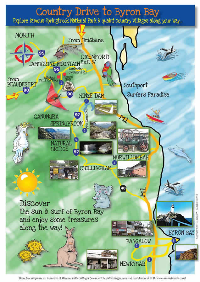
Country Drive to Byron Bay Map Guide
Explore famous Springbrook National Park & quaint country villages along your way…
With its lush rainforests, sun dappled bush walks, mesmerising waterfalls and diverse native wildlife, Tamborine Mountain is a place of unmatched natural beauty. Set in this beautiful landscape is our unique village community with its wineries, botanical gardens, art galleries and diverse restaurants and cafes.
You really do need a few days to enjoy everything our Mountain offers, however, by extending your stay you’ll also be able to explore our wider surroundings.
Go forth and explore the scenery, lookouts, waterfalls and the villages dotting the Country Lanes that wind their way to the magical coastal region known worldwide simply as Byron.
Just do it- This place is truly fantastic!
See the footer on this page for posts detailing an updated list of our current self-drive and local walking maps.
Fun interactive guide map for a great self-drive day trip from Amore B&B to Byron Bay
The Map Guide below has been created as an interactive map to have fun with by selecting different items of interest
JUST CLICK ON ANY OF THE IMAGES BELOW- YOU WILL BE SURPRISED!!
OR IF YOU WOULD LIKE A PRINT OUT OF THE MAP PLEASE CLICK HERE.
IF YOU WOULD LIKE DIRECTIONS ON GOOGLE MAPS PLEASE CLICK HERE.
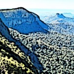
Natural Bridge
 Springbrook National Park covers an area of 6,197 hectares (15,310 acres) which makes it the second largest national park in the Gold Coast hinterland
In December 1994, Springbrook National Park became part of the Shield Volcano Group of the UNESCO World Heritage-listed Gondwana Rainforests of Australia
Springbrook National Park lies in the McPherson Range which is a remnant of the huge shield volcano that dominated the region 23 million years ago
It has a Jurassic Park setting – made up of an ecosystem of lush subtropical warm and cool temperate rainforests and open eucalypt forests, where closed canopies high overhead protect an amazing array of endangered and protected flora and fauna
At 900m, the national park can be up to 5°C cooler than the lowlands
Springbrook National Park is divided into four sections: Springbrook Plateau, Mount Cougal to the south east and Natural Bridge and Numinbah to the west
The park has nine walking tracks – seven in Springbrook Plateau, and one each in Natural Bridge and Mount Cougal
The national park showcases a world of strangler figs, vines, epiphytes, glow-in-the-dark mushrooms and worms, colourful wildlife and spectacular waterfalls, cascades and gorges
The park is filled with wildlife including lace monitors, black skinks, carpet pythons, frogs, crayfish and eels
More than 100 species of birds live in this park and visitors are most likely to hear, rather than see, the elusive and unique Albert’s lyrebird who lives here.
Springbrook
 Springbrook’s National Parks cover a wide area but there are three must-dos.
Canyon Gorge Walk: The wildlife that you’ll see along this 1hr and 20 minute walk includes land mullets, lyrebirds and painted crayfish. The walking track leads behind two waterfalls and on to Twin Falls.
Purling Brook Falls: We suggest you go to the car park and walk to the lookout to see these majestic falls. In March 2015, the John Stacey Suspension Bridge across Little Nerang Creek gorge was opened. The bridge is part of an upgrade of the Purling Brook Falls walking track circuit, one of Queensland's most popular national park tracks. A new section of track has replaced a previous section that was subject to landslips. Walk down to the bridge—about a 90 minute round trip—to enjoy a complete view of the spectacular Purling Brook waterfall. The bridge name honours the late John Stacey, a Springbrook builder who became a highly respected QPWS ranger known for his craftsmanship on building projects and his other contributions to management of the area’s parks
The Best of all Lookout: This has stunning views, as the name implies, so don’t forget your camera. Along this track (asphalt) you will pass the moss laden relics of the last ice age and the 2,000 year old Antarctic Beech trees. Very ‘Lord of the Rings’. An amazing 30 minute walk and not to be missed when visiting Springbrook. This track is located at the top end of Repeater Station Road.
Murwillumbah
 Murwillumbah: A visit to the recently upgraded Museum will give you a feel for this charming country town.
The Tweed Valley Art Gallery, found on the outskirts of town is a must visit. It is the best Regional Art Gallery Kay and John have come across. The Gallery celebrates the career, life and legacy of Australia’s most famous still life painter Margaret Olley and central to the Gallery is the actual, relocated home studio of this acclaimed artist.
It is one of most desirable places to live in Australia, based on natural beauty,welcoming locals and good infrastructure.
The picturesque town of Murwillumbah is located in the centre of the stunning Tweed Valley on the far north coast, just 15 minutes from pristine beaches, 75 minutes south of Tamborine Mountain, and 40 minutes north of Byron Bay.
Watched over by the awe inspiring majesty of Mt. Warning, and surrounded by 5 World Heritage National Parks the countryside around Murwillumbah is a blend of rolling hills and punctuated with hobby farms and small village communities.
The town itself has a lot to offer; From some of the best of Art Deco architecture to be found anywhere in the country to the award winning Tweed Valley Art Gallery. Murwillumbah has shopping for all manner of merchandise and dining options abound.
Newrybar

Newrybar is located on the Pacific Highway south of Murwillumbah. The small town has a quiet country atmosphere with an award-winning restaurant, local merchant, art and craft shops.
The Harvest Cafe is outstanding - an old bakehouse with heaps of character and great food (bookings are essential- see Kay or John). Even if you are not famished, poke your head in the door for a look-see, you will be surprised.
The surrounding countryside is dotted with farms producing fruit, vegetables, macadamia nuts and coffee bean plantations.
It is a short drive from Newrybar to Byron Bay. Travel to Newrybar to buy a coffee or have lunch and experience the buzz that the town inspires.
If you wish to explore the beautiful area, maybe take a swim at Killen Falls.

Give us a call on 55 453737 if you require any assistance
Bangalow
 Bangalow a small historic town with a relaxed, casual and fresh modern style and quaint rustic charm.
A Federation style village with great restaurants, retail and antiques stores and 15 minutes to Byron Bay.
It is said that the name ‘Bangalow’ meant either ‘a low Hill’ or a kind of palm tree in the language of the Banjalang Aboriginal people who lived in the area before European settlement in the 1840s.
Bangalow is at the centre of traditional dairy country, but sugar and, in more recent years, coffee production has added to the regional economy as has the influx of tourists.
Bangalow with its sophisticated charm, as the cafés, galleries, retail and antique establishments that dot the main street will attest is a must visit on your trip to Byron Bay.
One of the town’s little gems is the walking track that meanders along the edge of Byron Creek. The track emerges to a perfect spot for a picnic.
Chillingham
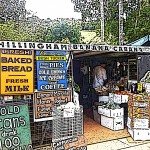 The village of Chillingham is the southern gateway to Springbrook National Park and the rock archway known as Natural Arch on your northern route from Byron Bay to Tamborine Mountain.
The mountain-fed waters form a stream which cascades through the roof of a cave into the effervescent rock pool below.
A glowworm colony takes centre stage at night and the area is alight with the magic of these ancient creatures.
The charming general store has a great garden area - enjoy tea and scones and country-style cooking.
Next door you will find one of the best shops for organic fruits and bush tucker specialties.
Banana Cabana Fruit Barn and Bush Tucker Gardens is the go to place.
Have a coffee or an ice-cream and if they have time you may have an opportunity to visit the orchard.
Located behind the village hall you will come across Crystal Waters Soaps.
Make sure you check out the old butchery.
Have a chat with John the artist in residence.
You may find that treasure you have been looking for in Chillingham.
Directions to Amore B&B
 How to find your way to Amore B&B
GPS Coordinates: 27.925071, 153.201009
If heading south take the motorway (M1) to Oxenford. The Oxenford exit is exit number 57. (Left lane)
Head up the Oxenford exit ramp, and veer right through a set of traffic lights.
Down the ramp and through a second set of traffic lights.
Straight ahead and you will then be on the road to Mt. Tamborine.
Follow the Oxenford-Tamborine Road for 20 minutes.
Upon reaching the top of the Mountain, you will come to a roundabout. Please turn right here (3rd exit).
There are shops, cafes, and the like on both sides of the street. You are now in Gallery Walk.
Continue on Gallery Walk for 700m, you will reach another roundabout. Go straight ahead.
We are the third property on your left immediately after this roundabout.
Kay and John look forward to welcoming you.
Amore B&B - 150 Long Road, Tamborine Mountain Qld 4272
Tel: 07 5545 2330 ![]()
Amore B&B
 Amore B&B is located at 150 Long Road on Tamborine Mountain.
Each of the four spacious rooms is themed to the English porcelain classics. The Doulton, Wedgewood, Country Rose, and Blue Delph. Soft furnishings match the themes and comfort is maximised with collectible antique furnishings from around the world. Timber framed windows enable mother nature to light up the rooms and when opened you can feel the fresh mountain air.
Please contact Kay or John at Amore B&B on 07 55452330 or visit the website for booking arrangements.
Amore B&B - 150 Long Road, Tamborine Mountain Qld 4272
Tel: 0![]() 7 5545 2330
7 5545 2330
CLICK HERE to visit our Wildlife and Marine Parks Map Guide
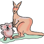
Want to cuddle a Koala? Feed Kangaroos in a free range environment?
See nocturnal animals in the light of day?
See possums, Multi- Coloured Australian Birds, Wombats, Tasmanian Devils, Emus and an array of Australian native wildlife?
What about Dolphins, Polar Bears, Crocs, Baby Tigers?
Then CLICK HERE to go to our Local Animals Post and Wildlife Parks Interactive / Printable Map Guide to point you in the right direction.
CLICK HERE to visit our Adventure Tamborine Style Map Guide
 Are you looking for an adventure getaway with a different twist?
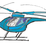
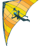
What about Whale Watching, Jet Boating, a High Ropes Experience, Sightseeing by Helicopter, Hot Air Ballooning or maybe Hang Gliding.
You are in the right place to make it happen.
CLICK HERE to go to our Adventure Tamborine Style Information Post and Interactive and Printable Map.
Directions from Beaudesert to Amore B&B
 How to find your way to Amore B&B
GPS Coordinates: 27.925071, 153.201009
From Beaudesert take the Beaudesert/ Beenleigh road (Route 92) which is well signed for Tamborine and Beenleigh.
You will travel for about 18 minutes (21.5 km)
You enter a large Roundabout at Tamborine Village, take the third exit, and you will be heading South-West towards Tamborine Mountain (Route 95).
You will now travel for 10.5 km. through the Rainforest as you wind your way up the mountain.
Turn left into Eagle Heights Road and you will travel 1.1 km to the Eagle Heights Roundabout. Take the 3rd exit into Long Road .
We are the third property on your left immediately after this roundabout.
Kay and John look forward to welcoming you to Amore.
Amore B&B - 150 Long Road, Tamborine Mountain Qld 4272
Tel: 07 5545 2330 ![]()
Directions from Southport to Amore B&B
How to find your way to Amore B&B from the Gold Coast
GPS Coordinates: 27.925071, 153.201009.
Via Smith Street or any of the other entry points join the M1 Motorway.
Proceed north along the M1 to the Oxenford exit, number 57.
Head up the Oxenford exit ramp, and veer left. Down the ramp and through a set of traffic lights.
You are then on the road to Mt. Tamborine.
You will notice the sign to Mt. Tamborine. Follow the Oxenford-Tamborine Road for 20 minutes.
Upon reaching the top of the Mountain, you will come to a roundabout with a fig tree in the centre. Please turn right there.
There are shops, cafes, galleries and the like on both sides of the street. This is known as Gallery Walk.
Still on Gallery Walk, you will reach another roundabout. Go straight ahead.
We are the third property on your left immediately after this roundabout.
Kay and John look forward to welcoming you.
Amore B&B - 150 Long Road, Tamborine Mountain Qld 4272
Tel: 07 5545 2330 ![]()
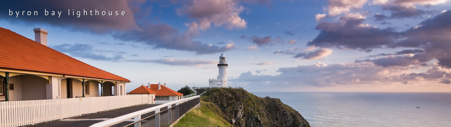
Byron Bay
Byron Bay is where you’ll finally dip your toes in the ocean.
This is the low-key, casual commercial heart of this coastal region and just as famous for dreadlocks and sarongs as it is for creative dining and luxury boutiques.
Visit the Cape Byron Lighthouse to see migrating whales, pods of dolphins playing in the surf and turtles swimming calmly by. From the lighthouse, walk to the most easterly point in Australia and then take a short drive to the famous Wategos Beach.
Byron Bay's natural credentials are impeccable. With its gorgeous beaches and lush green hinterland, this paradise casts a spell over everyone who goes there.
Humpback whales cruise past the headland, and hang-gliders ride the thermals above the Byron Bay lighthouse as you experience stunning views from Australia's most easterly point.
Today Byron Bay is a stylish must see destination with glorious beaches, and loads of style.
Enjoy your day!
Hang Gliding on Tamborine Mountain
Are you looking for an adventure getaway with a different twist?
What about Whale Watching, Jet Boating, a High Ropes Experience, Sightseeing by Helicopter, Hot Air Ballooning or maybe Hang Gliding.
You are in the right place to make it happen.
CLICK HERE to go to our Adventure Tamborine Style Information Post and then via that Post to our Interactive and Printable Map.
Hinze Dam

Hinze dam is approximately a 35 minute drive from Tamborine Mountain on your country drive to Byron Bay.
The recent construction upgrade has brought about many new exciting activities with places to explore and things to do including an interpretive center, a cafe with views, walking tracks, bike tracks, barbecue and picnic areas and much much more.
The peaceful surrounds and brilliant outlook (especially from the Cafe) make Hinze dam a great place to go to relax, refresh and rejuvenate.
Do not miss the interpretative center as it is interesting, informative and will make you visit to Hinze dam one to remember.
The walking/bike path along the dam wall includes interesting sign posted information about the dam construction and the local fauna, flora and marine life which make the Hinze dam prescient their home.
CLICK HERE to visit our recent Animals Post
 Want to cuddle a Koala? Feed Kangaroos in a free range environment?
See nocturnal animals in the light of day?
See possums, Multi- Coloured Australian Birds, Wombats, Tasmanian Devils, Emus and an array of Australian native wildlife?
What about Dolphins, Polar Bears, Crocs, Baby Tigers?
Then CLICK HERE to go to our Local Animals Post and Wildlife Parks Interactive / Printable Map Guide to point you in the right direction.
Witches Falls Cottages
Stay at Witches Falls Cottages - private cottages for couples

At Witches Falls Cottages we offer private accommodation for couples. Each of our cottages has a big double spa in the bathroom with that special outdoor feel created by a glass roof and glass sliding doors, a fireplace (seasonal) and a private outdoor area with a covered BBQ. We deliver your choice of Breakfast Hamper to your cottage each morning.
Please contact Daniela & David on 07 5545 4411 or visit our accommodation choices page if you would like any further information.
Download this Map
CLICK HERE TO DOWNLOAD A PDF VERSION OF THIS MAP
Download this Map
CLICK HERE TO DOWNLOAD A PRINTABLE VERSION OF THIS MAP
From Oxenford to Amore B&B
How to find your way to Amore B&B from the M1 at Oxenford
GPS Coordinates: 27.925071, 153.201009.
Proceed along the M1 to the Oxenford exit, number 57.
Head up the Oxenford exit ramp. Then Down the ramp and through the very prominent set of traffic lights.
You are then on the road to Mt. Tamborine.
You will notice the sign to Mt. Tamborine. Follow the Oxenford-Tamborine Road for 20 minutes.
Upon reaching the top of the Mountain, you will come to a roundabout with a fig tree in the centre. Please turn right there.
There are shops, cafes, galleries and the like on both sides of the street. This is known as Gallery Walk.
Still on Gallery Walk, you will reach another roundabout. Go straight ahead.
We are the third property on your left immediately after this roundabout.
Kay and John look forward to welcoming you.
Amore B&B - 150 Long Road, Tamborine Mountain Qld 4272
Tel: 07 5545 2330 ![]()