Brisbane’s Best Day Trip and Information Guide
A whole new world awaits you out there.
Escape to the country and discover the quaint villages, hamlets and settlements in your backyard. If it’s diverse scenery, fresh mountain air, antiques, old wares, great food and outstanding country hospitality that you are after, you are in the right place. Local villages and hamlets have it all in generous quantities and in a unique environment bursting with personality.
Go forth and explore – it is Brilliant!
This Map and information guide is one in a series of self-drive and walking map guides developed for our guests.
See the footer on this page for posts detailing an updated list of our current self-drive and local walking maps.
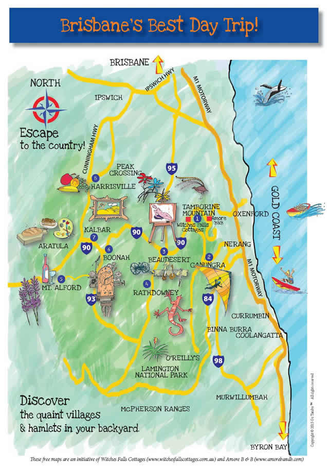
The Map Guide below has been created as an interactive map to have fun with by selecting different items of interest
JUST CLICK ON ANY OF THE IMAGES BELOW- YOU WILL BE SURPRISED!!
OR IF YOU WOULD LIKE A PRINT OUT OF THE MAP PLEASE CLICK HERE.

Tamborine Mountain
TAMBORINE MOUNTAIN
C ountry lanes meander throughout the mountain directing you to exciting outcomes.
You'll find wineries, historic pubs, eclectic gift shops and beautiful art galleries.
Waterfalls, rainforest walking tracks and views to the coast and the ranges.
The name is of Aboriginal origin and has nothing to do with the musical instrument.
Tamborine Mountain is located 30 minutes from the Gold Coast and one hour from Brisbane.
The geological origin of the plateau is the result of eruptions from a huge shield volcano in the Mount Warning area of northern New South Wales about 20-23 million years ago, which smothered the surrounding landscape with layers of basalt lava flows.
Tamborine Mountain was opened to selection in 1875, with the first sawmill established there in 1882 by Gustave Murray Carter and the Hon. Cecil Peary. It was steam-powered and the area was abundant with trees to fell. However the project proved nonviable due to the difficulties transporting milled timber from the mountain.
Due to access issues the population remained small for many years. By the early 1900s that changed and in 1904 the Beaudesert Times reported: ”Tamborine Mountain is a very different place to what it was a few years ago. About five years ago there were only five families on the northern end of the mountain. Now there are enough people from here to start a dancing club and a tennis club.”
From 1918 to 1925 rapid land subdivision on Tamborine Mountain, including the 1920-21 creation of North Tamborine and Eagle Heights, was the most active period of history for subdivision until 1958.
Many of the mountain’s new residents were retirees, attracted to the mountain for health reasons.
The emergence of Tamborine Mountain as a tourism destination had its genesis in the development of traditional B&B’s and Guesthouses.
Tourists from Brisbane and the surrounds seeking to unwind in a restful and relaxing atmosphere flocked to the B&B’s in the area.
Nothing has changed. Amore B&B continues the tradition. Experience great hospitality, extensive local knowledge of all that Mt. Tamborine and the surrounds has to offer, welcoming, inviting and with personal attention, we are always ready to show you a brilliant time.
From the 1950s the pace of land clearance quickened as a number of dairy farms were subdivided into residential blocks. Soon the cream carrying service from the mountain was discontinued and many of the local farmers turned to avocados and fruit. Even in those early days the mountain was recognised as an attractive tourist and holiday destination.
Tamborine Mountain was inhabited by Aborigines for tens of thousands of years and was the territory of the Wangerriburra family group.
Until it was opened for selection in 1875 it was covered with subtropical rainforest. In that year, the first white settler, John O’Callaghan, selected a parcel of land on the Mountain.
Much clearing for agriculture took place, though efforts were made to protect the natural values of the area. Witches Falls National Park (now a part of the Tamborine National Park) being declared as Queenslands first National Park in 1908.
Information taken from Beaudesert Shire: Thematic Historical Overview by Helen Bennett and from Scenic Rim Regional Council data.
Tamborine Mountain Country Markets - 2nd Sunday each month 8am- 2pm
Tamborine Mountain School Markets - Last Sunday each month 8am-2pm
Tamborine Mountain Local Producers Markets Every Sunday8am-12noon
CLICK HERE to Visit our Wildlife and Marine Parks Map Guide

Want to cuddle a Koala? Feed Kangaroos in a free range environment?
See nocturnal animals in the light of day?
See possums, Multi- Coloured Australian Birds, Wombats, Tasmanian Devils, Emus and an array of Australian native wildlife?
What about Dolphins, Polar Bears, Crocs, Baby Tigers?
Then CLICK HERE to go to our Local Animals Post and Wildlife Parks Interactive / Printable Map Guide to point you in the right direction.
Harrisville
 HARRISVILLE
The town of Harrisville was first established in 1863 when Robert Dunn selected a block of land from the old Mt Flinders sheep station.
This block was selected for its views of the plains in the foreground and the Great Dividing Range in the distance and it became Harrisville.
Encouragement by the then Queensland Government for people to settle in rural areas led to the establishment of the Ipswich Agricultural Reserve, focused around the Warrill and Warroolaba Creeks.
Land was surveyed into small blocks and made available to settlers. It quickly emerged that the land was fertile and by 1864 some 27 farms had been established.
The American Civil War had caused a world shortage of cotton and local settlers began growing cotton. John and George Harris opened a general store and cotton ginnery. A railway branch line was built in 1882, creating an added incentive to development.
The town soon had its own hospital, school of arts, school, churches, bank and post office. Dairying later became the main source of income for local families. A condensed milk factory was established and was later sold to Nestles.
We thank the Scenic Rim Regional Council for compiling this data.
Boonah
 BOONAH
Boonah is the Fassifern’s largest town centre.
In the early 1880s the Blumberg Brothers opened the town store, a decision that prompted James Johnson to select his first block. Other selectors began taking up land, driven by the Queensland Government’s policy of encouraging closer settlement.
Farmers moved into the area in the mid 1870s, and many of them had opened their own businesses. A sawmill, hotels, general stores and a butcher’s shop followed in an area originally called Blumbergville Dugandan.
The arrival of the railway in September 1887 prompted residents to suggest the shorter name Boonah, which is said to be the aboriginal word for bloodwood tree.
The Milbong Council began in 1880, establishing its headquarters at Peak Crossing. However in 1888 the office moved to Boonah, in recognition of the town’s growth.
Land adjacent to the High Street was subdivided and sold and the town grew.
By 1890 Boonah contained a number of public buildings and over the years it established itself as the main service centre for surrounding rural enterprises.
The rural sector continued to grow too, thriving on the rich agricultural and grazing land. Dairying brought prosperity into the 1890s and continued to be a key local industry until the dairy deregulation in the late 1990s caused the industry to consolidate.
Based on information taken from The Fassifern Story by CK Pfeffer and from the Scenic Rim Regional Council.
Boonah Country Markets 2nd and 4th Saturday of each month - 7am-12 noon
Mt. Alford

MT. ALFORD
Mt Alford is an historic town situated at the foothills of the Teviot Range.
It was previously called Reckumpilla, but was renamed Mt Alford after Thomas Alford who arrived to manage Coochin Coochin Station in 1868.
Homestead settlement began in the open country in the early 1870s and the township began in the 1880s.
The Mt Alford school began on April 4, 1888 and continues to operate today. Mt Alford is a small town but what it lacks in size it makes up for in good old fashioned country hospitality.
As well as the school there is the famous Mt Alford Pub, and nearby the renowned Kooroomba Winery and Lavender Farm.
The School of Arts has long played an important role in local life and once hosted a performance by crime writer Agatha Christie, who was a guest at Coochin Coochin.
The quaint Mt Alford Store building still stands but is currently not being used as a general store.
We acknowledge the Scenic Rim Regional Council for compiling this data.
Mount Alford Artisans Market
11AM – 5PM 1st Saturday of each month at Mount Alford Hall
Rathdowney
 RATHDOWNEY
The town of Rathdowney, which lies about 32kms south of Beaudesert, was developed during the early 1900s as a small service centre to the new farming districts.
The Beaudesert Tramway opened to Innisplain in 1903 and proved such a success that by 1906 there were moves to have the line extended to Rathdowney.
The tramway extension was opened in 1911 and Rathdowney developed as the district centre.
The Stretton family erected the Rathdowney Hotel in the same year, and the Commercial Banking Company opened a branch office.
The Enrights of Beaudesert established a branch store retailing groceries, clothing and haberdashery until January 1971.
We again acknowledge the contribution of the Scenic Rim Regional Council in compiling this data.
Beaudesert
BEAUDESERT
 The land surrounding the town of Beaudesert was originally the traditional land of the Yugambeh people.
During the late 1820s the district was explored by officials associated with the penal settlement at Moreton Bay, who noted the suitability of the well-watered grasslands for pastoral purposes, and the useful stands of timber in the surrounding ranges.
In 1842 the first squatters took up land along the Logan and Albert Rivers. Until the 1860s pastoral interests, sheep and cattle, dominated the economic activity in the district.
In the early 1870s the town of Beaudesert originated as a privately surveyed town intended to service the expanding agricultural settlements.
By the late 1880s Beaudesert had emerged as the principal commercial and administrative centre of the district.
The early 1900s subdivision of freehold estates provided further impetus for the expansion of timber getting and agriculture, especially dairying. Pig raising and fodder production became important adjunct activities to dairying and until the 1930s depression the town of Beaudesert boomed, consolidating its position as the principal administrative and service centre in the district.
Two meat processing plants were established near Beaudesert in the 50s, providing much-needed local employment. From the 1960s to the 1990s there was a shift away from dairying towards cattle grazing in the area. Struggling farmers on small acreages were encouraged off the land, and local butter and milk factories gradually closed.
Information taken from Beaudesert Shire: Thematic Historical Overview by Helen Bennett and we acknowledge the Scenic Rim Regional Council in the compiling of this data.
Beaudesert Market Fest
1st Saturday of each month 7am-12noon
Lost World Valley
LOST WORLD VALLEY
 Lost World is a hidden plateau, a green shelf on Razorback Mountain, discovered by the O’Reilly family.
The original Lost World homestead, Cedar Glen, still stands and offers farm stay experiences to visitors.
The homestead was built in 1901 by Edgar Stephens who fled life in the city of Brisbane to start a dairy farm at Coopers Plains. He took up land in the Lost World in 1882 and continued to farm with his sons until he died in 1941. The home still sits on 1050 acres and has been maintained in its original condition.
Spectacular scenery and absolute peace abound in the Lost World Valley.
We again acknowledge the contribution of the Scenic Rim Regional Council in compiling this data.
CLICK HERE to visit our Adventure Tamborine Style map Guide

Are you looking for an adventure getaway with a different twist?
What about Whale Watching, Jet Boating, a High Ropes Experience, Sightseeing by Helicopter, Hot Air Ballooning or maybe Hang Gliding.
You are in the right place to make it happen.
CLICK HERE to go to our Adventure Tamborine Style Information Post and Interactive and Printable Map
How about a Country drive to Byron - CLICK HERE to visit our Map Guide
H ow about a Country Drive to Byron Bay?
Byron Bay's natural credentials are impeccable. With its gorgeous beaches and lush green hinterland, this paradise casts a spell over everyone who goes there.
Travel to Byron Bay via the scenic inland trail passing through many interesting towns, villages and hamlets along the way. The scenery is fantastic!
Humpback whales cruise past the headland, and hang-gliders ride the thermals above the Byron Bay lighthouse as you experience stunning views from Australia's most easterly point.
Today Byron Bay is a stylish must see destination with glorious beaches, and loads of style.
CLICK HERE to go to our Country Drive to Byron Bay Post and Interactive / Printable Map.
Directions from Oxenford to Amore B&B

How to find your way to Amore B&B from the M1 at Oxenford
GPS Coordinates: 27.925071, 153.201009.
Proceed along the M1 to the Oxenford exit, number 57.
Head up the Oxenford exit ramp. Then Down the ramp and through the very prominent set of traffic lights.
You are then on the road to Mt. Tamborine.
You will notice the sign to Mt. Tamborine. Follow the Oxenford-Tamborine Road for 20 minutes.
Upon reaching the top of the Mountain, you will come to a roundabout with a fig tree in the centre. Please turn right there.
There are shops, cafes, galleries and the like on both sides of the street. This is known as Gallery Walk.
Still on Gallery Walk, you will reach another roundabout. Go straight ahead.
We are the third property on your left immediately after this roundabout.
Kay and John look forward to welcoming you.
Amore B&B - 150 Long Road, Tamborine Mountain Qld 4272
Tel: 07 5545 2330 
Amore B&B

Amore B&B is located at 150 Long Road on Tamborine Mountain.
Each of the four spacious rooms is themed to the English porcelain classics. The Doulton, Wedgewood, Country Rose, and Blue Delph. Soft furnishings match the themes and comfort is maximised with collectible antique furnishings from around the world. Timber framed windows enable mother nature to light up the rooms and when opened you can feel the fresh mountain air.
Please contact Kay or John at Amore B&B on 07 55452330 or visit the website for booking arrangements.
Witches Falls Cottages
Stay at Witches Falls Cottages - private cottages for couples

At Witches Falls Cottages we offer private accommodation for couples. Each of our cottages has a big double spa in the bathroom with that special outdoor feel created by a glass roof and glass sliding doors, a fireplace (seasonal) and a private outdoor area with a covered BBQ. We deliver your choice of Breakfast Hamper to your cottage each morning.
Please contact Daniela & David on 07 5545 4411 or visit our accommodation choices page if you would like any further information.
Download a copy of this Map
CLICK HERE TO DOWNLOAD A PRINTABLE VERSION OF THIS MAP

